Threat Awareness Can’t Stop in the Briefing Room
Patrol officers make split-second decisions with whatever information they had at their last shift briefing. Suspects stay free. Officers walk into situations without context. Communities lose confidence. The challenge lies in the information never reaching the officer making the stop.
Versaterm OpsIntel for Patrol puts real-time crime intelligence directly in officers’ hands in the field. Structured bulletins, collaborative discussions, live mapping and connected case data replace the bulletin board and buried email chains, ensuring the right officer has the right information at the right moment.
Stale Intelligence Creates Blind Spots
When officers act on yesterday's information, they miss patterns, misread risk and make stops without context. Versaterm OpsIntel for Patrol delivers verified, current intelligence to any device in real time.Cases Stall When Information Stays Siloed
The arrest that didn’t happen because no one connected the vehicle description to the open BOLO is a failure the community pays for. Versaterm OpsIntel for Patrol links the people, places, activities and assets that matter across every record in the system.An Hour of Delay is an Hour a Suspect Stays Free
Real-time information sharing compresses the time between a crime occurring and a pattern being recognized, reducing time-to-arrest and lowering community risk.Crime Connector
When Records Are Disconnected, the Pattern That Breaks the Case Stays Hidden.
A potential suspect may appear in a bulletin, a discussion thread, a data feed and an open case, appearing as four separate, unconnected records. The analyst who could have spotted the pattern never had a complete picture. Crime Connector links every mention of a person, place, asset or activity across the platform, surfacing the associations that are key to breaking cases.
When every data point is connected, a single new piece of intelligence can illuminate an entire network of activity, turning a routine stop into a significant arrest.
Automated Bulletin Management
A BOLO in an Email Inbox Is Not a BOLO.
High-priority alerts sent by email reach officers at their desks, not officers on foot at midnight making a stop on someone who matches the description. Static bulletin boards go unread. Shift briefings capture one moment at the start of a shift. Anything that develops after that has no guaranteed path to the officer who needs it. Automated Bulletin Management delivers real-time alerts, BOLOs and critical updates directly to every officer on every device, the moment they are issued.
Officers can create, comment on and act on bulletins from any device in the field, including alerts from partner agencies, ensuring cross-jurisdictional intelligence reaches the officer who needs it, not just the inbox of the supervisor who forwarded it.
Collaborative Discussion Board
Investigations Stall When Critical Knowledge Lives in One Person’s Head.
Leads that should connect don’t because the officer who made the observation is off shift. Context that took a detective months to build disappears when they transfer. The Collaborative Discussion Board gives every officer a persistent, searchable record of active investigative threads, ensuring institutional knowledge survives shift changes and informs every officer working the case.
Discussions can be shared with partner agencies for cross-jurisdictional collaboration and viewed in card, grid or map format, putting the full picture in front of every responder who needs it.
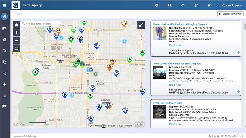
Map Viewer
Crime Patterns Are Invisible Until You Visualize Them.
A cluster of incidents obvious on a map stays undetected in a report queue for weeks. By the time the pattern is recognized, the window to intervene has passed. The Esri-based Map Viewer transforms data points into a real-time operational picture that is color-coded, filterable and time-sliced, so emerging patterns surface before they escalate.
Customizable icons, zoom settings and default map layers let officers configure the view that works for their patrol area, keeping attention focused on the intelligence that matters most.
Case Management
Cases Without a Knowledge Trail Repeat Themselves.
When case history lives in individual officers’ notes and memories, agencies face the same offenders with the same methods of operation repeatedly, without the benefit of what the last investigator learned. VersatermOpsIntel for Patrol is the knowledge trail. Every bulletin, discussion, data feed and connected record builds a searchable, centrally stored picture of the fait do people, places and patterns that inform future investigations.
Continuous communication between internal and external agency partners keeps all relevant parties current, reducing the overhead of coordination while lowering both agency and community risk.
Search Elasticity
Manual Searches Across Disconnected Systems Miss the Connection That Matters.
While an officer is running an NCIC check during a stop, there may be a recent BOLO, a bulletin or an intelligence thread sitting in Versaterm OpsIntel for Patrol that matches the vehicle description or the person in front of them. Without a fast way to surface it, that connection goes unnoticed.
Search Elasticity pulls together all structured and unstructured data across the platform in seconds, including partial plates, nicknames and address fragments, so officers can quickly check whether anything in the system matches what they are looking at in the field.
Partners We Serve
Whitepaper
Reducing Crime Through Real-Time Information Sharing and Collaboration
Learn how Versaterm OpsIntel for Patrol is empowering agencies to reduce crime and strengthen community trust by turning real-time information sharing into an operational advantage.
DownloadThe Latest on Versaterm OpsIntel for Patrol
Move From Handwriting to Crime-Fighting
Close the gap between intelligence you collect and the patrol officers who needs to act on it