
Rethinking Public Safety Drone Management
Few moments in public safety carry as much uncertainty as the time between receiving a call and arriving at the scene. A call comes in about a person with a firearm at the edge of town, but their exact location is unclear. For years, the only way to find out was to go in.
With Versaterm DroneSense, public safety drone management extends the workflows dispatch and command use into the field, so responders can learn more about a scene before they step into it. Watch an incident play out below, then take a closer look at the capabilities behind it.
Closing the Information Gap Before Arrival
Every responder knows the challenge of approaching an incident with more questions than answers. Where is the person? What are they holding? How many ways are there on and off the property? On many calls, those answers arrive only once personnel are close enough to be at risk.
Aerial context changes the order of operations. A thermal-equipped aircraft can reach a location ahead of ground units and help locate a person in dark, open terrain that is difficult to search on foot. It can also reveal what the person is holding and what exits exist. Details like this shape every decision that follows, and they’re available before anyone has to approach.
The value extends beyond rural properties. Dense neighborhoods, large venues and multi-story buildings pose similar challenges, and connected public safety drone management can help responders understand a scene quickly in any environment.
Public Safety Drone Management Starts With the Call, Not Later
Drones are only as effective as the process around them. When a program operates separately from the dispatch center, a launch can mean paging a pilot, switching systems and coordinating airspace by phone. Each step adds time.
Versaterm DroneSense is designed to remove those steps. With a connection to Versaterm CAD, drones can be assigned and tracked alongside patrol, fire and EMS units, supporting Drone as First Responder programs. Native FAA LAANC integration supports airspace authorization directly through Versaterm DroneSense, and Versaterm Airspace adds a real-time view of other aircraft in the skies above. Versaterm DroneSense also gives agencies the flexibility to manage supported aircraft from multiple manufacturers within a single platform, even as their fleets evolve over time.
One Live View for the Field and the Communications Center
Radio is still how most response information travels. Someone describes what they see, someone else interprets it and the picture changes slightly with each retelling.
Live video sharing replaces that relay with a common view. As a core part of connected public safety drone management, Versaterm DroneSense gives dispatchers, responders and command shared situational awareness, while secure links make it possible to share video with partner agencies. Everyone involved, from officers in the field to supervisors in the communications center, has access to the same information in real time, even during multi-jurisdictional responses.
Time and Distance Give Responders Options
Real-time information gives responders more options for managing an emergency as it unfolds. With connected public safety drone management, agencies can provide a clearer understanding of the situation before personnel arrive, giving them more time to determine the best course of action.
That added visibility creates room to work. Officers can set a perimeter and control access while the drone keeps the scene in view. Supervisors can bring in specialized resources, and someone can begin a conversation from a safe distance. The aircraft doesn’t resolve the situation on its own, but continuous observation can give crisis negotiators and command staff more time to pursue a resolution that avoids escalation. The same visibility can also support responder safety on the way in, by showing whether a path of approach is clear before units commit to it.
Records That Capture What Reports Often Miss
Reports capture outcomes, but they rarely capture the reasoning behind them. What responders observed, when they saw it and how those details influenced the decision to hold position or approach can be difficult to reconstruct later. Yet these are often the very details agencies are asked to explain.
Versaterm DroneSense automatically captures flight data and mission details for reporting and review. That gives agencies a more complete record for training, internal review and public transparency without asking responders to document it from memory after a long shift.
Public Safety Drone Management That Fits the Way Agencies Work
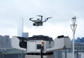
Public safety drone management systems deliver the greatest operational value when they connect to the tools agencies already use instead of adding another screen to watch. Versaterm DroneSense is built on that principle, bringing drone operations together with CAD, other agency technology and existing workflows. Versaterm Airspace now extends that connected approach with real-time awareness of the airspace above a response.
The goal is straightforward: give responders the information they need before they arrive so every decision that follows is better informed. Connect with our experts to learn more about how Versaterm DroneSense and Versaterm Airspace can enable your agency to bring greater awareness to every response.


