Comprehensive Situational Awareness & Drone Collaboration
Versaterm DroneSense delivers a comprehensive drone operations platform tailored for public safety agencies, empowering them to de-escalate critical incidents and save lives. The system supports both locally piloted missions, such as tactical operations, search and rescue, and remote Drone as First Responder (DFR) deployments. It offers seamless live streaming and real-time collaboration across teams and jurisdictions. With a full compliance toolkit, Versaterm DroneSense simplifies the complexities of drone program management, ensuring transparency and accountability.
Drone as First Responder
From the ability to capture high-definition images or videos from any angle to rapid reaction times, drones have become essential when it comes to responding to perilous scenarios where each second counts.
Mixed Fleet Compatible
Versaterm DroneSense provides ultimate mission flexibility by integrating with a wide variety of tablets and sensors, as well as Blue UAS Cleared and NDAA-compliant drones.
Live Video Streaming
Secure, low-latency streaming available internally and externally, with unlimited viewers. Easily share real-time feeds via text or email alerts.
Misson Collaboration
Seamlessly coordinate and collaborate across multiple agencies and jurisdictions, maximizing effectiveness during joint operations.
Who We Serve
Law Enforcement
Whether you’re with a local, state or federal law enforcement agency, we can help you successfully use drones to aid with numerous situations, including crimes-in-progress, accident and crime scene reconstruction, SWAT operations and large event overwatch.Fire and Rescue
The use of drones in fire services has become invaluable. We help agencies of all sizes incorporate drones to aid with pre-fire planning, hot spot detection, managing a live scene, post-fire mapping, search and rescue operations and more.Emergency Management
Whether you want to expand your capabilities over a large area or help victims alongside (or in advance of) rescue personnel, we can help you coordinate your drone teams to effectively respond to a variety of different emergency scenarios.Solution Overview
Situational Awareness
By utilizing Versaterm DroneSense, your team can swiftly and effectively react to crises, making better decisions and proactively identifying potential hazards before they become serious problems that jeopardize lives or property.
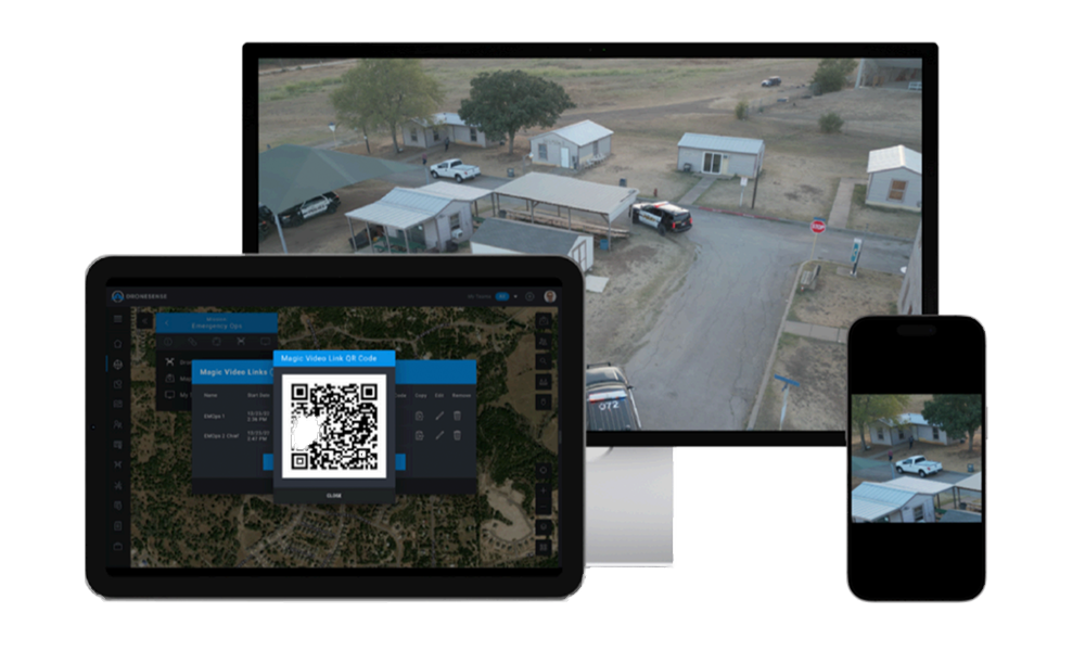
Shareable Video Link
Agencies can send a secure link via email or text to cooperating institutions through built-in collaboration tools, giving access to video streamed during a mission. Secure sharing ensures all necessary parties have the most up-to-date information while eliminating confidential details. With improved coordination, Versaterm DroneSense helps support a faster multi-agency response.
Mobile Streaming & Tracking Technology (MSAT)
Versaterm DroneSense turns every cell phone or tablet into part of your command center action, capturing live-stream video and GPS locations from the boots on the ground.
Advanced Geospatial Features
Map management tools help you navigate situations from the routine to the extraordinary. From map caching and data layers to offline sharing, we have you covered.
Hardware Integrations
Blue UAS-Cleared & NDAA Compliant
-
Parrot ANAFI UKR
-
Vantage Robotics Vesper2
-
Vantage Robotics Trace
-
Inspired Flight IF800
-
Inspired Flight IF1200A
-
Freefly Systems AstroMax
-
Skydio X10
- Fotokite Tethered drone (non Blue UAS-certified)
Other Drone Integrations
-
DJI Avata2
-
DJI M4TD
-
DJI Dock 1, 2, 3
-
DJI M3T
-
DJI 4E
-
DJI Matrice 30/M30T
-
DJI Matrice M300 RTK
-
DJI Matrice M350 RTK
-
DJI Matrice M200 & M210
-
Autel Evo Max 4T/4T XE/4N
-
Autel Evo II Pro
Other Integrations
- MatrixSpace Radar Airspace
Support & Training
We offer comprehensive technical assistance, including 24/7 US & UK based support for urgent issues, to address the unique challenges faced by public safety agencies and other organizations utilizing our platform. This support encompasses everything from initial setup and configuration to ongoing maintenance and troubleshooting, ensuring that users can rely on their systems in critical situations.
Led by our team of public safety drone experts, we can deliver onboarding training courses including our mobile platform in-depth analysis, DFR set-up, remote operator training, dock and system integrations. Our courses will enable your agency to enhance operational efficiency and effectiveness and enable pilots to manage the wide range of incidents they will support in your drone program.
Drone as First Responder
Versaterm DroneSense supports Drone as First Responder (DFR) initiatives, allowing agencies to launch a remotely operated drone directly from dispatch in response to a 9-1-1 call. DFR gives operators and stakeholders an “eye in the sky” that can help assess and identify potentially dangerous incidents. This comprehensive view supports officer safety through improved situational awareness.
Versaterm DroneSense offers seamless live streaming, allowing for real-time collaboration across teams and jurisdictions. Automated record keeping of flight logs can be turned into reports or dashboards made available to the public, encouraging transparency and helping improve public trust.
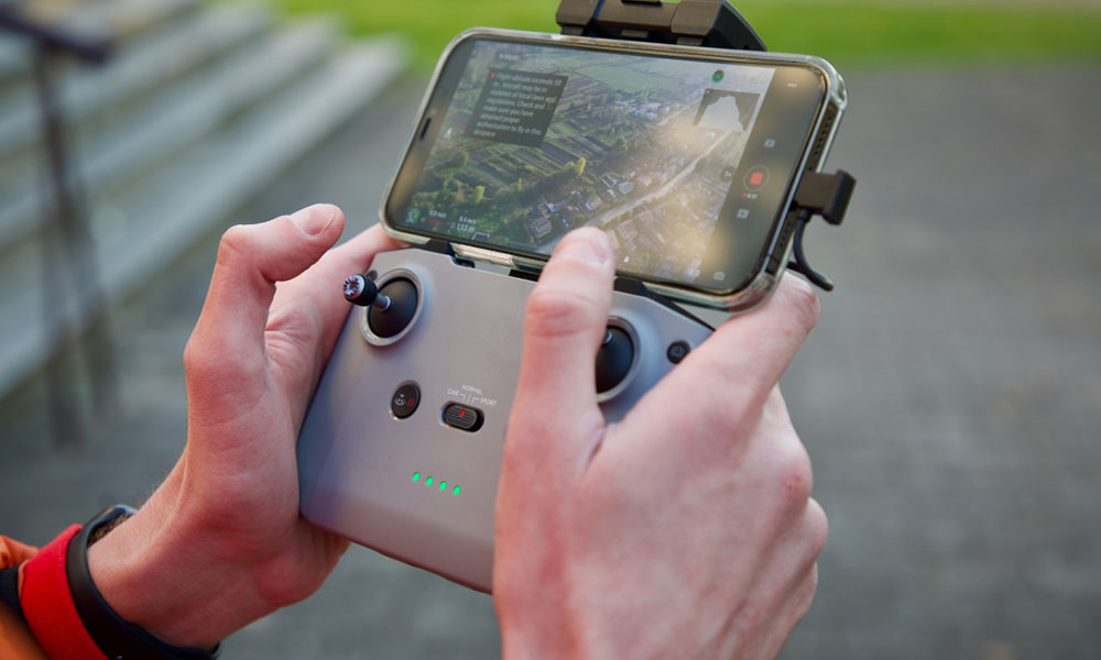
DroneSense Pilot
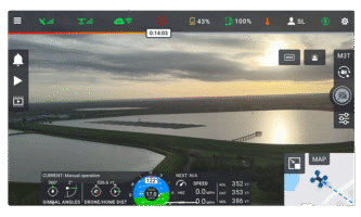
Take control of your missions with a consistent flight control interface, automatic flight logging and remote live streaming. Pilots can view relevant telemetry data including height, speed, relative drone position and orientation to pilot and gimbal angle.
DroneSense Pilot offers the best visual or thermal camera for any operation and lets users toggle between sensors and unique access features, like zoom controls and thermal palettes. With a persistent map view, pilots can maintain awareness of the aircraft’s position and orientation at all times, even while viewing the full video screen.
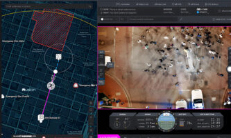
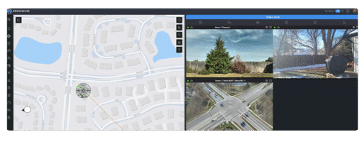
DroneSense OpsHub
With secure access to live data, your command center can pull data from multiple sources into one central and easy-to-use application. Operators can create groups of custom map objects such as hazards, towers and takeoff and landing zones that are visible to pilots and command staff.
Gain access to a wide range of overlays like weather radar, U.S. wildfires and USNG as well as any public ESRI base layers that may be relevant for your agency. DroneSense OpsHub allows operators to create comprehensive feature layers with customizable lines and polygons that are visible to other Versaterm DroneSense users in the operation.
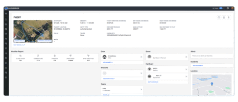
DroneSense Airbase
Easily organize your people, flights, missions and hardware using our complete system of record. Our hardware management system stores each asset, tracks its location and automatically applies the hours it was used after every flight. Relevant program data can be found easily through our robust sorting and filtering options.
Clearly visualize what is happening within drone programs by using map and calendar views to understand when and where flights and other activities occur. Program administrators can grant users access to necessary information through Roles and Teams, while ensuring sensitive data is protected with granular permission options.
Response Team
Agencies can operate with confidence backed by the Versaterm DroneSense Response Team. Comprised of former first responders, our team of specialists has decades of field experience. We offer logistical support, on-site training and troubleshooting of service-impacting issues.
The Versaterm DroneSense Response Team can partner with you to help scope your mission and provide a clear path of action. We can help your agency determine the appropriate equipment and staffing needed to achieve your objectives, supporting more streamlined operations.
Data Security
Versaterm DroneSense surpasses the stringent requirements set forth by industry standards, legal mandates, and regulatory frameworks related to information security, including SOC 2 Type II, CMMC 2.0 Level 2, and ISO27001, among others.
The Latest From Versaterm
Everything You Need to Fly and Manage Your Drone Program
Take control of your missions and see how we can help manage your organization’s life-saving drone program simply, securely and reliably.